 文章来源地址https://www.toymoban.com/news/detail-637842.html
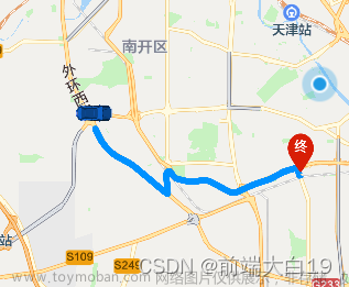
//地图
		getLocationDian(e1, e2) {
			console.log(e1, e2);
			let self = this;
			self.xx1 = [];
			self.xx2 = [];
			self.points = [];
			// self.markers=[]
			console.log(self.markers, '======>marks');

			// self.$jsonp(url, data).then(re => {
			// 	var coors = re.result.routes[0].polyline;
			// 	for (var i = 2; i < coors.length; i++) {
			// 		coors[i] = coors[i - 2] + coors[i] / 1000000;
			// 	}
			// 	coors.forEach((item, index) => {
			// 		if (index % 2 == 0) {
			// 			self.xx2.push(item);
			// 		} else {
			// 			self.xx1.push(item);
			// 		}
			// });

			// 	self.xx1.forEach((item, index) => {
			// 		self.points.push({
			// 			longitude: item,
			// 			latitude: self.xx2[index]
			// 		});
			// 	});
			// 	self.setDateByPoints(self.points);
			// });
			wx.request({
				url: 'https://apis.map.qq.com/ws/direction/v1/ebicycling', //仅为示例,并非真实接口地址。
				data: {
					from: e1,
					to: e2,
					key: '3MSBZ-*********-C2UL7-PGYA3-2TFCU'
				},
				header: {
					'content-type': 'application/json' // 默认值
				},
				success: res => {
					console.log(res, 'cccccccc');
					self.xx1 = [];
					self.xx2 = [];
					self.points = [];
					// console.log(res.data.result.routes[0].polyline,909090);
					var coors = res.data.result.routes[0].polyline;
					for (var i = 2; i < coors.length; i++) {
						coors[i] = coors[i - 2] + coors[i] / 1000000;
					}
					// console.log(coors,'coors==================')
					coors.forEach((item, index) => {
						if (index % 2 == 0) {
							self.xx2.push(item);
						} else {
							self.xx1.push(item);
						}
					});
					self.xx1.forEach((item, index) => {
						self.points.push({
							longitude: item,
							latitude: self.xx2[index]
						});
					});
					self.setDateByPoints(self.points);
				}
			});
		},
		setDateByPoints(points) {
			console.log('setDateByPoints', points);
			let that = this;
			let color = '#ffd500';
			that.polyline = that.computePointsSpeed(points);
			console.log(that.polyline, '数据');
			if (!that.polyline.length) {
				that.polyline = [
					{
						points: points,
						color: color,
						arrowLine: true, //带箭头的线
						width: 8
					}
				];
			}
			// if (that.maxSpeed) {
			// 	that.maxSpeed.iconPath = '../../static/icon/address_icon.png';
			// 	that.maxSpeed.width = 24;
			// 	that.maxSpeed.height = 24;
			// 	that.maxSpeed.id = 2;
			// 	that.maxSpeed.callout = {
			// 		color: '#5d5d5d',
			// 		fontSize: 14,
			// 		borderRadius: 6,
			// 		padding: 8,
			// 		bgColor: '#fff',
			// 		content: `极速 ${this.covertSpeed(this.maxSpeed.speed)} km/h`
			// 	};
			// }
			let start = points[0];
			let end = points[points.length - 1];
			start.id = 1;
			start.width = 35;
			start.height = 35;
			start.iconPath = '../../static/icon/address_icon.png';
			end.id = 3;
			end.width = 35;
			end.height = 35;
			end.iconPath = '../../static/icon/address_icon.png';
			console.log(start, '======>箭头');

			that.markers.push(start, end);
			this.setCenterPoint(start, end);
		},
		// 根据速度计算路线颜色
		computePointsSpeed(points) {
			let lineColor = '#0080FF';
			let list = [];
			if (!points || !points.length) {
				return list;
			}
			let lastArr = [];
			let lastSpeed = 0;
			for (let i = 0; i < points.length; i++) {
				let speed = this.covertSpeed(points[i].speed);
				if (!this.maxSpeed) {
					this.maxSpeed = points[i];
				} else {
					if (points[i].speed > this.maxSpeed.speed) {
						this.maxSpeed = points[i];
					}
				}
				if (i === points.length - 1 || !speed) {
					// 还剩最后一个不计入
					continue;
				}
				let nextPoint = points[i + 1];
				let nextSpeed = this.covertSpeed(points[i + 1].speed);
				if (!nextSpeed) {
					continue;
				}
				lastSpeed = speed;
				if (!lastArr.length) {
					lastArr.push(points[i], nextPoint);
				} else {
					lastArr.push(nextPoint);
				}
			}
			this.centerPoint = points[Math.round(points.length / 2)];
			// console.log("centerPoint", this.centerPoint)
			if (!list.length && lastArr.length) {
				list.push({
					points: lastArr,
					color: lineColor,
					arrowLine: true, //带箭头的线
					width: 8
				});
			}
			return list;
		},
		// 地图中心点 (计算3个点的中心点)
		setCenterPoint(start, end) {
			this.longitude = (start.longitude + this.centerPoint.longitude + end.longitude) / 3;
			this.latitude = (start.latitude + this.centerPoint.latitude + end.latitude) / 3;
			let distance1 = this.getDistance(start.latitude, start.longitude, this.centerPoint.latitude, this.centerPoint.longitude);
			let distance2 = this.getDistance(this.centerPoint.latitude, this.centerPoint.longitude, end.latitude, end.longitude);
			const distance = Number(distance1) + Number(distance2);
			console.log('计算两点之间的距离', distance1, distance2, distance);
			if (distance < 200) {
				this.scale = 17;
			}
			if (distance >= 200 && distance < 1000) {
				this.scale = 15;
			}
			if (distance >= 1000 && distance < 5000) {
				this.scale = 13;
			}
			if (distance >= 5000 && distance < 10000) {
				this.scale = 12;
			}
			if (distance >= 10000 && distance < 15000) {
				this.scale = 11;
			}
			if (distance >= 15000 && distance < 50000) {
				this.scale = 10;
			}
			if (distance >= 50000 && distance < 200000) {
				this.scale = 8;
			}
			if (distance > 200000) {
				this.scale = 5;
			}
		},
		// 速度转换 m/s -> km/h
		covertSpeed(ms) {
			if (ms <= 0) {
				return 0.0;
			}
			const kmh = ms * (60 * 60);
			return parseFloat(String(kmh / 1000)).toFixed(2);
		},
		// 计算两坐标点之间的距离
		getDistance: function(lat1, lng1, lat2, lng2) {
			let rad1 = (lat1 * Math.PI) / 180.0;
			let rad2 = (lat2 * Math.PI) / 180.0;
			let a = rad1 - rad2;
			let b = (lng1 * Math.PI) / 180.0 - (lng2 * Math.PI) / 180.0;
			let r = 6378137;
			return (r * 2 * Math.asin(Math.sqrt(Math.pow(Math.sin(a / 2), 2) + Math.cos(rad1) * Math.cos(rad2) * Math.pow(Math.sin(b / 2), 2)))).toFixed(0);
		},
<map id="map1" :longitude="longitude" :latitude="latitude" :markers="markers" :scale="scale" :polyline="polyline"></map>markers: [
{
id: 1,
latitude: 30.338206,
longitude: 120.222305,
iconPath: '../../static/icon/address_icon.png',
width: '40',
height: '40'
},
{
id: 2,
latitude: 30.348206,
longitude: 120.222305,
iconPath: '../../static/icon/address_icon.png',
width: '40',
height: '40'
}
], // 标记点集合
latitude: '30.338206',
longitude: '120.222305',
scale: 12, // 地图缩放比例
points: [],
xx1: [],
xx2: [],
polyline: [
{
points: []
}
] //文章来源:https://www.toymoban.com/news/detail-637842.html
到了这里,关于规划路线(微信小程序、H5)的文章就介绍完了。如果您还想了解更多内容,请在右上角搜索TOY模板网以前的文章或继续浏览下面的相关文章,希望大家以后多多支持TOY模板网!


